


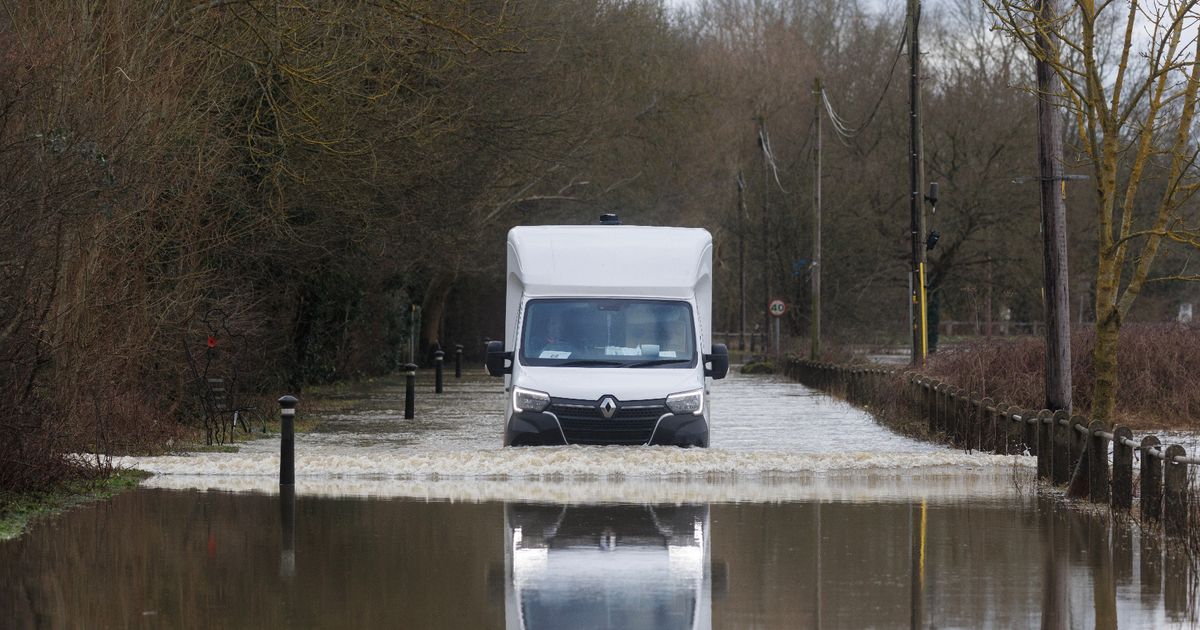
Heavy rain has caused river levels around the county to rise

Further rainfall is expected across Kent over the coming weekend.(Image: Getty Images/Dan Kitwood)
Flooding is expected in multiple parts of Kent today (January 16) as a new batch of warnings and alerts have been issued. Following persistent rainfall yesterday, which prompted a yellow weather warning over much of the county, river levels in several key areas have risen considerably.
This has resulted in the Environment Agency issuing two flood warnings and 11 flood alerts along key rivers, as showers fell on already saturated ground due to the recent Storm Goretti. Affected areas include those bordering the rivers Medway, Stour, Teise, Beult, Eden and Eden Brook.
Alerts are issued at three different levels: alerts; warnings; and severe warnings. Where warnings are in effect, residents are advised that flooding is “expected” to take place and those in the area should begin to act on any flood plans and activate any flood protection products you may have.
Alerts meanwhile advise that flooding is “possible” and residents in affected areas are being urged to “prepare”. Essential preparations include getting together a bag of “vital items” such as medication and insurance documents, and to check flood warnings. You can read the full advice here.
Met Office forecasts anticipate today will be generally drier than yesterday, though there remains the possibility of isolated rain showers developing, which could turn heavy at times. Tonight will begin dry, but see cloudy skies and mist sweeping over the south east region before a band of showery rain arrives.
Coastal showers will then follow, making for a cloudy start to Saturday (January 17) with light rain and drizzle dying out. The day will see light winds as temperatures linger around 10C while more overnight mist and fog is possible.
The period between Sunday (January 18) and Tuesday (January 20) generally looks to be cloudy with a chance for more rain outbreaks and limited clear spells. Light winds will continue, alongside prevalent fog patches, and temperatures will sit around normal for the time of year.
Find further details on today’s flood alerts and warnings below.
Kent flood warnings and alerts – Friday, January 16
Warnings
River Medway between Forest Row and Penshurst
Flood warning area: River Medway between Forest Row and Penshurst, including Ashurst and Hartwell.
River Teise and Lesser Teise between Horsmonden and Claygate
Flood warning area: River Teise and Lesser Teise between Horsmonden and Claygate, including Sheephurst Lane and Maidstone Road.
Alerts
River Darent from Westerham to Dartford
Flood alert area: River Darent from Westerham to Dartford, including Brasted, Sundridge, Chipstead, Dunton Green, Otford, Eynsford and South Darenth.
Rivers Eden and Eden Brook
Flood alert area: Rivers Eden, Eden Brook and Kent Ditch from Blindley Heath to Penshurst including Edenbridge and Hever.
Lower River Medway
Flood alert area: River Medway from Hampstead Lock at Yalding to Allington Lock, including East Farleigh, Wateringbury, Teston and Teston Park, Tovil and Maidstone including Millennium Park.
River Bourne from Hadlow to East Peckham
Flood alert area: River Bourne from Hadlow to East Peckham, including Golden Green and Little Mill.
Middle River Medway
Flood alert area: River Medway from Penshurst to Hampstead Lock at Yalding, including the Leigh Flood Storage area, the Ensfield Road, Tonbridge, Paddock Wood, the Hop Farm, East Peckham, Branbridges and Hale Street.
Upper River Medway
Flood alert area: River Medway from Forest Row to Penshurst, including Ashurst.
River Teise and Lesser Teise area from Horsmonden to Yalding
Flood alert area: River Teise and Lesser Teise area from Horsmonden to Yalding, including Claygate, Collier Street and Laddingford.
River Teise area from Lamberhurst to Goudhurst
Flood alert area: River Teise area from Lamberhurst to Goudhurst, including the River Bewl and tributaries of the River Teise.
River Beult from Pluckley and Bethersden to Stilebridge
Flood alert area: River Beult from Bethersden and Pluckley to Stile Bridge, including Smarden, Headcorn, Staplehurst and Hawkenbury.
River Rother and its tributaries from Turks Bridge to the Royal Military Canal
Flood alert area: River Rother and its tributaries from Turks Bridge to the Royal Military Canal, including Crowhurst Bridge, Etchingham, Robertsbridge, Salehurst and Bodiam.
Upper River Stour
Flood alert area: Communities on the Great Stour from Charing Heath to the A2070 including Ashford, communities on the East Stour, communities on the Whitewater and Ruckinge Dykes and the Aylesford Stream.
Get more news from KentLive straight to your inbox for free HERE


